Managing The Retreat From Rising Seas

This report is composed of 17 individual case studies. Each one tells a different story about how states, local governments, and communities across the country are approaching questions about managed retreat. Together, the case studies highlight how different types of legal and policy tools are being considered and implemented across a range of jurisdictions - from urban, suburban, and rural to riverine and coastal - to help support new and ongoing discussions on the subject.

Mainstreaming Climate Action Into Sustainable Development

This webinar, the first of a series of three dedicated to the Partnership in Action report, will see how countries are integrating climate action into domestic policy, planning, budget, and SDG agendas across government in the COVID-19 era, including using climate action as a basis for economic recovery and involving many varied actions. It will offer snapshots on how countries are facing up to COVID, health issues, inclusive growth, and adaptation, as well as their efforts to engage youth and make climate action gender responsive.

Louisiana's Vanishing Coast: Before And After Images Show A Decade's Loss

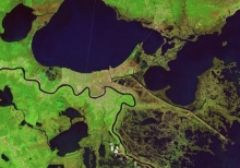
The scars of coastal loss, accelerated by Hurricane Katrina in 2005, still can be seen on the wetlands surrounding New Orleans, visible in before and after images taken by combined camera and sensor devices aboard NOAA Landsat satellites. Wetlands surrounding Delacroix are shown a week before Katrina, with normal vegetation showing up as bright green and water as blue. The Caernarvon Freshwater Diversion Project releases water from the Mississippi River into the Big Mar, and it eventually flows southeast through these wetlands.

Louisiana's Disappering Coast

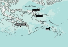
Plaquemines is where the river meets the sea. On maps, it appears as a thick, muscular arm stretching into the Gulf of Mexico, with the Mississippi running, like a ropy blue vein, down the center. At the very end of the arm, the main channel divides into three, an arrangement that calls to mind fingers or claws, hence the area's name - the Bird's Foot. Seen from the air, the parish has a very different look. If it's an arm, it's a horribly emaciated one. For most of its length - more than sixty miles - it's practically all vein.

Louisiana Waterways Among Most Polluted In Nation, Report Says

A 10-year-old girl walks to the edge of the Kansas River in Topeka, Kansas, rolls up a note, and slips it into a plastic bottle before sending it downstream. Sixteen years, hundreds of miles, and two rivers later, Michael Coyne-Logan, an educational facilitator for Living Lands and Waters, hoists it from the Mississippi River in St. Louis. That is one bottle among the millions of pounds of trash that he and his cleanup crew have collected in recent years as they try to make a dent in the enormous amount of garbage floating down the Mississippi.

Louisiana Conservation Servitudes

A conservation servitude, known as a conservation easement in other states, is a voluntary deeded restriction on your property that prevents it from being developed in certain ways. However, it does not mean that you relinquish ownership of the property. You can still sell, mortgage, and pass the land to your children. Conservation servitudes are flexible in that you can pick restrictions and requirements that fit your conservation vision.

Louisiana Coastal Resilience Game

What does the future hold for culture, industry, and ecology along the coast of Louisiana? What can be done about it? The Louisiana Coastal Resilience Game allows participants to implement protective and restorative efforts of varying cost and estimated degrees of impact along Louisiana's coastline and observe potential future outcomes under different policy and weather scenarios.

Losing Ground

In 50 years, most of southeastern Louisiana not protected by levees will be part of the Gulf of Mexico. The state is losing a football field of land every 48 minutes -- 16 square miles a year -- due to climate change, drilling and dredging for oil and gas, and levees on the Mississippi River. At risk: Nearly all of the nation's offshore oil and gas production, much of its seafood production, and millions of homes.