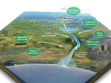
The Challenge Of Tracking Nutrient Pollution 2,300 Miles

Nitrogen and phosphorus are essential nutrients - yet too much of a good thing is not always a good thing. Scientists are investigating nutrient pollution down the Mississippi River. Each spring, water flows approximately 2,300 miles down the Mississippi River, beginning its journey at Lake Itasca in northern Minnesota and emptying into the Gulf of Mexico. Along the way, streams and rivers accumulate nutrients that run off the land and into the waterways, and eventually these nutrients enter the Gulf of Mexico.

Epa Illegally Lowered Allowed Oxygen Content Of North Shore Rivers: Suit

Before EPA approved a decision by the Louisiana Department of Environmental Quality to reduce the required dissolved oxygen level of the stream segments to 2.3 milligrams per liter from March through November, all of the affected waters were supposed to have oxygen levels no lower than 5 milligrams per liter for freshwater segments and no lower than 4 milligrams per liter for estuarine rivers and streams year-round in areas where freshwater and saltwater systems mix.

Pontchartrain Environmental Atlas

Management of nitrogen loading into the watershed is a feasible proposition even with the likely further urban expansion on the northern shore of the Lake. The consequences of future nitrogen loadings resulting from population growth on the north shore of Lake Pontchartrain can be compensated for by rather rudimentary sewerage treatment of existing non-point sources, from treatment or diversion of pumped urban runoff, and by sealing the leakage of water passing through the Bonnet Carre Spillway.

Modeling The Gulf Of Mexico

The "Modeling the Gulf" middle school science curriculum was compiled and developed to align with research being conducted by the Consortium for Ocean-Microbial Interactions in the Ocean (CSOMIO). The CSOMIO project is working to fill critical gaps in our ability to numerically model the transport and fate of oil in coastal waters. This middle school science curriculum contains five lesson plans related to ocean modeling, including the fields of biogeochemistry, fluid dynamics, and microbiology.

Macroinvertebrates

Different types of macroinvertebrates have different requirements to survive. Some require cooler temperatures, relatively high dissolved oxygen levels or certain habitats. Other macroinvertebrates may be able to survive in less-than-ideal conditions - where there are low dissolved oxygen levels or more sediment - or where the water temperature is warmer. Again, there aren't any "bad" macroinvertebrates, but the population present may indicate that there are bad stream conditions in which only the "strong" can survive.

Creek Critters

Audubon Naturalist Society's Creek Critters app walks you through finding and identifying the small organisms - or critters - that live in freshwater streams and creating stream health reports based on your findings." Creek Critters acts as a tool when identifying macroinvertebrates and allows users to contribute to a community science proje