Preserving Our Place- A Community Field Guide To Engagement, Resilience, And Resettlement: Community Regeneration Int He Face Of Environmental And Developmental Pressues

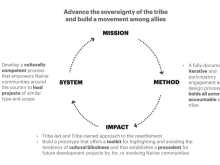
Community is self-defined and complicated. This field guide does not define what a community is or is not, but it is intended for those communities whose lifeways are threatened by environmental change that has exceeded the carrying capacity of the community's social and ecological infrastructure. The problem is more often defined as risks to infrastructure, but the loss of lifeways is not irrelevant. We suggest that social concerns must not be displaced in the face of risk, and that cultural continuation and survival is as important as infrastructure.

Plaquemines Parish Comprehensive Master Plan: Coastal Protection And Restoration

Coastal restoration plays a paramount role in protecting Plaquemines' citizens from storm surge and maximizes protection will allow for the expansion of Plaquemines' economic base. The purpose of the coastal restoration element of the Comprehensive Master Plan is to review and assess coastal restoration plans and activities in Plaquemines Parish. The goal of this section is to help the Parish government more effectively plan and prepare for future growth in a manner that offers maximum protection for residential, commercial, and industrial investment.

Patterns In Submerged Aquatic Vegetation In The Lower St. Johns River, Flordia, From 2001-2019

To understand resiliency of submerged aquatic vegetation (SAV) communities with distance from the river mouth, SAV monitoring data, consisting of nine taxa, were analyzed in the lower St. Johns River, Florida, from 2001 to 2019. Patterns were evaluated with changes in salinity, turbidity, and weather events (e.g., hurricanes).

Participatory Modeling: Connecting Local Knowledge And Scientific Understanding

During five meetings in 2018, representative community members in St. Bernard Parish were involved in a fact-finding and participatory modeling activity. Areas of risk were identified, and potential natural and nature-based solutions were tested through modeling. The models were adjusted based on the community group's feedback. This summary outlines how this project moved forward, what was discovered through this new process, and if the community found value in the approach.

Nurdle Patrol

Nurdle Patrol started in November 2018 after a large number of plastic pellets washed up on Mustang and North Padre Islands in Texas during September 2018. We are looking to gather information about where nurdles are located, remove the nurdles from the environment, and create awareness about the nurdle issue." To access the Nurdle Patrol training video, click here

Mississippi River Diversion Could Save Louisiana's Drowing Coast

Engineers are working to help reconnect the Mississippi River to Louisiana's sediment-starved wetlands in an effort to rebuild some of the land that is disappearing at a rate of almost 11,000 acres a year - or roughly a football field an hour. The diversions will be major civil works projects without compare. The work will require careful scheduling to maintain flood protection as the Mississippi River levee comes down and a diversion gate is put in its place. And that will be the easy part.

Marine Debris Art

Lula Gil founded Water Journey, a movement communicating sustainability through art and water sports. Her art consists of transforming plastic waste she finds at Rio de la Plata River, into pieces of art to raise awareness about the plastic pollution affecting the seas and inspire people to connect with Mother Nature through their habits. For her, art evokes sensitivity and helps to understand this topic from an intimate perspective. Here is a quick and easy step-by-step guide with a few tips to create plastic art.

Land Area Change In Coastal Louisiana (1932 To 2016)

Coastal Louisiana wetlands are one of the most critically threatened environments in the United States. These wetlands are in peril because Louisiana currently experiences greater coastal wetland loss than all other States in the contiguous United States combined. The analyses of landscape change presented here have utilized historical surveys, aerial, and satellite data to quantify landscape changes from 1932 to 2016.