Losing Ground

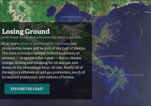
In 50 years, most of southeastern Louisiana not protected by levees will be part of the Gulf of Mexico. The state is losing a football field of land every 48 minutes -- 16 square miles a year -- due to climate change, drilling and dredging for oil and gas, and levees on the Mississippi River. At risk: Nearly all of the nation's offshore oil and gas production, much of its seafood production, and millions of homes.
Living Shorelines

Living shorelines' is a term used to define a number of shoreline protection options that allow for natural coastal processes to remain through the strategic placement of plants, stone, sand fill, and other structural and organic materials. Living shorelines often rely on native plants, sometimes supplemented with stone sills, on-shore or off-shore breakwaters, groins, or biologs to reduce wave energy, trap sediment, and filter runoff, while maintaining (or increasing) beach or wetland habitat (National Research Council, 2007).

Iseechange

ISeeChange is a global community that posts about what they notice changing in the environment using our platform and mobile tools. Each post is synced with weather and climate data and broadcast to the community to investigate bigger picture climate trends. Over time, community members can track how climate is changing, season to season, year to year, and understand the impacts on daily life.

Importance Of Mangrove Forests

Mangrove ecosystems provide a multitude of goods and services for people, including: provision of food and clean water (provisioning services), influence climate regulation, soil composition regulation and disaster risk reduction (regulating services), and recreational and spiritual space (cultural services).

Hurricanes And Rising Seas: Coastal Flooding In An Uncertain Future

With rising sea levels, coastal environments and communities are increasingly vulnerable to flooding from strong storms, including hurricanes. Join Teresa Crean from RI Sea Grant and URI's Coastal Resources Center and host Holly Morin of the Inner Space Center for a live discussion about climate change, coastal storms and the tools to help us prepare for flooding in an uncertain future.

How Levee Wars Make Floods Worse

In our latest Vox + ProPublica collaboration, we dive into how a structure that's designed to protect us from floods, may actually be making them worse. High levees come at a high cost, often pushing water into communities that can't afford the same protection. To demonstrate, we built a giant, scientific model of a river with levees - complete with adorable tiny houses.

How Humans Sank New Orleans

Below sea level. It's a universally known topographical factoid about the otherwise flat city of New Orleans, and one that got invoked ad nauseam during worldwide media coverage of Hurricane Katrina and its catastrophic aftermath in 2005. Locally, the phrase is intoned with a mix of civic rue and dark humor. It's also off by half. Depending on where exactly one frames the area measured, roughly 50 percent of greater New Orleans lies above sea level. That's the good news.

How A Delta Is Formed

Since the beginning of human civilization, people have settled along rivers and on the fertile deltas created by them. The sediment carried and deposited by mighty rushing waters creates land rich in nutrients and ideal for crops and livestock. Where there are uninhibited rivers, there is new, rich land, and where such resources abound there are people.

Homeowners Elevate Houses

Elevating a home for flood protection is a major task that can be expensive and lead to many anxious moments, but it can also give homeowners a sense of security when the next tropical storm comes ashore. LSU AgCenter correspondent Craig Gautreaux has the story of a historic home that is being raised to protect it from future storms.