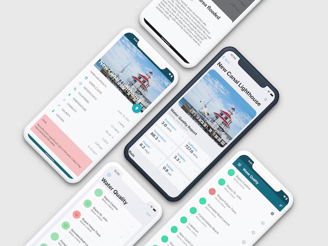
Since 2001, we've been keeping you up to date with the latest conditions around the lake and in our basin. With our data, communities can better understand the status of popular recreation sites and have greater insight into what they can expect for water quality conditions in the estuary.
There are always inherent risks associated with recreation in natural waterways. Please use extreme caution and swim at your own risk.
Water Quality Results FAQs
What Do the Colors Red and Green Mean?
Data marked red is above criteria, or fail on the day and time measured.
Data marked green is below criteria, or pass on the day and time measured.
Data marked green is below criteria, or pass on the day and time measured.
How Do We Measure Results?
We utilize the Beach Action Value (BAV), described in EPA's 2012 Recreational Water Quality Criteria (RWQC). The BAV value is a tool for determining a “do not exceed” value for beach notification purposes. For Enterococci, the BAV described in the 2012 RWQC is 70 CFU/100mL. The presence of Enterococci in the water indicates the water has been contaminated with fecal waste from warm-blooded animals. Or more simply, the presence of these microorganisms indicates the possible presence of other pathogens.
A location will be marked red if the Enterococci sample exceeds a bacterial density of 70 CFU/100mL. Data marked red is above criteria.
A location will be marked green if the Enterococci sample does not exceed a bacterial density of 70 CFU/100mL. Data marked green is below criteria.
A location will be marked red if the Enterococci sample exceeds a bacterial density of 70 CFU/100mL. Data marked red is above criteria.
A location will be marked green if the Enterococci sample does not exceed a bacterial density of 70 CFU/100mL. Data marked green is below criteria.
Does Rainfall Affect the Results?
Yes! Lake Pontchartrain's water quality may be negatively impacted by rainfall runoff. Heavy rains may cause wastewater treatment systems or collection systems to overflow and ultimately contaminate the lake. If it has rained in your area in the past three days, the runoff could pollute the region of the lake near you. Always use caution when recreating in Lake Pontchartrain.
Lake & Coast

What Do We Test For?
Microbial Indicators of Fecal Pollution
Indicator organisms are essential tools used to assess water quality and protect public health. When sewage leaks into lakes and rivers, the public can be exposed to harmful bacteria. We monitor water quality by measuring three different indicator organisms: Enterococcus, E. coli, and Fecal Coliform. These organisms serve as reliable and easy-to-measure indicators of potential fecal contamination in water. When they are present in water, it indicates the presence of fecal matter from warm-blooded animals, which can carry harmful pathogens.
The choice of which indicator to use has evolved over time. In the past, fecal coliform bacteria were commonly used to measure water quality. However, the US Environmental Protection Agency (EPA) and the State of Louisiana now recommend using Enterococcus as the primary indicator organism. It has specific criteria for safe water quality, aiming to reduce the risks of waterborne illnesses for recreational activities.
EPA studies suggest that fecal coliform is a poor-predictor of gastrointestinal disease and recommended the use of Enterococcus. Pontchartrain Conservancy still samples and analyzes fecal coliform, but we now only highlight when Enterococcus values exceed the Beach Action Value of 70 CFU/100mL to be consistent with the 2012 Recreational Water Quality Criteria (RWQC).
Also of note, we collect measures related to E. coli. Certain strains of this microorganism make the news periodically with the contamination of raw vegetables or ice cream. We collect samples for analysis because this microorganism is shed from the gut of humans and warm-blooded animals. The State of Louisiana does not currently utilize this indicator as a criterion, but we believe making this measure will provide additional insights into the health of the estuary.
Salinity
Salinity is how we measure the amount of salt in water. We usually measure it in parts per thousand (ppt). For example, the ocean has an average salinity of 35 ppt, which means that in every 1000 grams of seawater, or one liter, thirty-five (35) grams are salt. Typically, Water is called "fresh" if it has less than 2 ppt, and “brackish” above this concentration.
In places like estuaries, where freshwater mixes with salty ocean water, the salinity is usually lower than in the open ocean. Salinity can change in different parts of the estuary, with the tides, and how much freshwater flows in. Sometimes, saltwater stays at the bottom, forming saltwater wedges in lakes and rivers. This is because the heavier density of salt water will prevent an even mix with the fresh water above it.
To measure salinity, we use a special device that checks how well water can conduct electricity. This measure depends on the amount of dissolved salt. The more salt, the better the water conducts electricity.
Salinity is important because it affects the kinds of fish and plants that can live in an area. Changes in salinity, like when the Mississippi River-Gulf Outlet closed, have had a big impact on Lake Pontchartrain. It influences where certain fish and plants thrive, and it's essential for cypress swamp restoration, which helps protect us from storms. Measuring salinity is crucial for understanding and protecting our water, and also provides insights to locations suitable for cypress tree reforestation efforts.
Temperature
Temperature is a critical factor in aquatic ecosystems because it impacts various aspects of water quality. It significantly influences how aquatic plants and organisms function. In simple terms, higher temperatures lead to increased metabolic rates, affecting growth and decay in aquatic life. Increased activity means that more oxygen is needed, which can deplete oxygen levels in the ecosystem.
Here's why it matters:
Oxygen Depletion: Increased temperatures can reduce the amount of oxygen that can dissolve in water. In an environment where growth and decay are both accelerated, and oxygen is less available, DO concentrations can drop significantly.
Extreme Temperatures: Extremely high temperatures, above 35°C, can damage biological enzymes necessary for metabolism. This can impact an organism's ability to process nutrients and can even lead to death. It can also affect the survival of eggs and nymphs.
What Causes Temperature Changes?
Natural and human factors can affect the temperature of aquatic ecosystems:
Natural Sources: Sunlight and the atmosphere can transfer heat to or from the water. Sunlight warms the water, while the atmosphere can either absorb heat from or transfer heat into the water, depending on temperature differences.
Tributaries: The temperature of water entering a lake can be influenced by tributaries. Depending on their flow, these tributaries can introduce warmer or cooler water, affecting the overall temperature.
Human Activities: Human actions, such as industrial and municipal discharges, can impact water temperature. For instance, power plants use water to cool equipment, which can lead to warmer water returning to the source. Similarly, stormwater runoff from hot surfaces like parking lots can carry heat into nearby waters, affecting temperature.
Water Visibility
Water visibility is a measure of how deep light can penetrate water. Clear water has few tiny particles or algae, so you can see far. But muddy water, with lots of tiny bits in it, scatters light and doesn't let light go very deep. This matters because it affects the kinds of life that can thrive in the water.
Clear water is great for underwater plants. They can get more sunlight, make oxygen, and become homes for fish and other creatures. Water can naturally get cloudy sometimes, like when there are storms, wind, or changes in light.
In the past, we saw changes in water visibility in Lake Pontchartrain when people dredged for clams. Dredging mixed up bottom sediment into the water and took away filter-feeding clams that help keep water clear. While dredging is no longer allowed, we can also see changes in visibility with the opening of the Bonet Carre spillway. When the spillway is opened, the Mississippi River brings muddy water.
To measure water visibility, we use something called a Secchi disk. It's a black and white disk we lower into the water until we can't see it anymore, and we measure how deep it went. The clearer the water, the deeper it goes.
Dissolved Oxygen
Dissolved Oxygen (DO) is one of the most important measures we collect for assessing the health of water for aquatic wildlife. Fish, bivalves, and water plants need a sufficient amount of DO to live, just like we need oxygen in the air.
DO can be dissolved into water in different ways. It can slowly transfer in from the air, but oxygen transfer happens especially when the water's surface gets moved by wind and waves. People can also help by using machines to add oxygen to the water, like in fish tanks or dams. Much of our technical assistance helps with making sure oxygen is injected into wastewater treatment systems. Things like water depth, temperature, and saltiness can influence the concentration of DO.
Dissolved oxygen can provide insights during algal blooms. When a bloom event occurs, DO will increase during the night hours, usually above normal conditions. On the other hand, when there's too little DO, it can be bad news for aquatic life. Overcrowded waters or pollution can consume too much DO, making it tough for many creatures to survive.
If you have further questions, reach out to us at waterquality@scienceforourcoast.org.
Get Involved
Discover the many ways you can contribute to save Southeast Louisiana. Take part in a tree planting, aid in gardening and instruction at our Lighthouse, or giveback in other ways. We need you today!
Support Our Work
By supporting Pontchartrain Conservancy, you have the opportunity to help save the Louisiana you know and love. Your support enables us to build a sustainable, prosperous, and resilient region together.

